CommentsGUEST COMMENTARY--Transportation politics are in place to make a major disruption to communities by the mistaken belief that light rail can be put into existing boulevards. This is contained in the November ballot Proposition M to increase the sales tax and extend it.
Putting light rail into existing boulevards at grade would kill off miles of businesses for lack of good access, would make greater traffic congestion including CO2 emissions and increase development at destinations that would further imbalance the ratio of travel demand to infrastructure capacity.
Among the supposed political motivations to do this is the belief that less VMT and CO2 emissions will result, BUT THAT IS NOT SO! The real motivation is to add Real Estate to the tax base and please developers. However, the consequences have dire affects for the City and County of LA while conflicting with affordable living and achieving environmental goals.
A profound incompatibility exists in trying to mix vehicular and rail transit modes in the same right of way. The State Public Utility Commission (PUC) requires a physical separation between the two different modes – which create major difficulties in operational and turning movements for vehicles and rail itself when light rail is put in the center of existing boulevards. Among those obstacles are the lack of opportunities to make left turns resulting not only in business failures, increased congestion and CO2 emissions but also with very much increased intrusions of traffic into adjacent residential neighborhoods to make up for the lack of left turn opportunities.
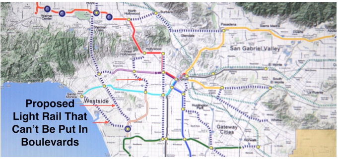
The Metro list of boulevards to have light rail include Lincoln, Sepulveda, Santa Monica, La Brea, Van Nuys Boulevards and a number of others. As seen in the accompanying plan image, this would invalidate much of what Metro would intend to do in the greater LA area.
In the recent EIR of the Westside Mobility Plan study, the impacts for both the centrally located light rail, which was then abandoned due to impacts, and the last alternative with an exclusive bus lane near the curbs were acknowledged as having “significant and unavoidable impacts.” Both of these conditions made more congestion and GHG emissions than not doing the projects at all. That makes such a ½ cent tax increase a waste of taxpayer money and offers sound reasons for not doing the projects. And more to the point of this discussion -- not voting for the tax increase!
The ½ cent sales tax increase has been in the lobbying pipeline for some time, which probably means few politicians had been given truthful disclosure on the matter of these recent revelations in the Westside Mobility Plan study.
The intent, to first use light rail, was to achieve a higher capacity mode to move person trips. The failure is due to the incompatibility of modes which degraded each of the rail and vehicle purposes and abilities. Mixing cars, trucks, buses and light rail becomes a traffic quagmire. Rail is supplemental to the vehicular network. And the ‘low hanging fruit’ of exclusive corridors like the Expo and Orange lines have been picked.
The way to add the desired capacity to remove congestion, and the “CO2e” associated with it, while making truly “rapid bus transit,” is by designing some roadways as continuously flowing traffic facilities and incorporating the quantitative aspects of efficiency through controlled traffic management and the qualitative aspects of urban design concerned with function and experience at the pedestrian scale. Vehicular modes need to be controlled and made efficient; place making for pedestrians and bike riders need appropriate space and protection.
Continuous flowing traffic (CFT) makes better use of the existing boulevard roadways giving the higher capacity that is required to remove those traffic bottleneck and gridlock conditions. The CFT roadway facility is designed to remove obstruction to flowing traffic, would still have cross traffic at grade as is needed in the urban context and would have traffic signals controlled by the LA system called Automated Traffic Surveillance and Control (ATSAC) system now used in some 4400 applications in locations throughout LA.
A CFT roadway can have community compatibility with low and safe speeds, a constant 30 mph for example, but would provide faster travel time because signals would be timed to ensure green lights on the timed and spaced roadway intersections giving a mile of travel each two minutes any time of the day. Lanes of flowing traffic could have as much as twice the current lane capacities that stop and go traffic operate at and with current technology and driver abilities.
This roadway joins the overall Southern California Association of Governments (SCAG) planning strategy to reduce VMT and GHGs while developing sustainable communities in cities of all sizes and fixing many of those existing problems currently in the denser and overdeveloped areas of LA. Rightly so the approach stresses ‘Network Management’ and the transforming of vehicular efficiency with CAFÉ standards (54mpg by 2025) as well as increased use of electric and fuel cell vehicles.
In that, vehicular mileage is comprised of greater than 95% of County travel in the movement of goods and people, and with rail less than 2%, an urban roadway system with capacities between that of a regular boulevard and that of a freeway becomes a needed and timely addition to solving traffic problems in selected corridors. LA County has the Traffic Signal Synchronization Program (TSSP) which is effective on arterials where signals are spaced greater than two miles apart. But now there can be the CFT low cost, compatible urban roadway system at grade that deals with signalization being closer than TSSP.
Existing and future vehicle and traffic management technologies can be added to the basic CFT roadway architecture that comprises the ability to provide “continuous flowing traffic on urban interrupted streets.” The consistency of the system provides a safer driving environment for human drivers and can be combined with the autonomous vehicles of the future.
It is important to acknowledge some of these objectives to reduce VMT and GHG that can be achieved with the following policies: Disperse future growth to within the contained area called LA County to not attract overdevelopment in communities that will then make congested streets and excessive GHG emissions. This is an essential part of the planning strategy to reduce VMT and CO2e by making the length of the “averaged trips” shorter by having more complete and balanced communities dispersed throughout the County which by proximity of destinations will reduce average trip length.
Two things about the implied lack of Metro planning. There first is the fact that it is not feasible to put light rail into existing boulevards successfully eliminating most of their intended plans. Then there is the idea of trying to bring greater land use densities into the already high density areas of the LA Basin which already have congestion and communities in protest to preserve and protect themselves from drastic character change and gentrification. In contrast, it is the suburbs that need the job growth and increased urbanity to foster greater productivity within sustainable communities whose proximity of land uses decrease VMT and GHG emissions.
In the LA Basin you fix the traffic congestion with higher capacity and in the suburbs you structure diverse land use growth with evolving higher capacity in selected growth corridors.
That brings us to the present situation that would fund a political battle and planning disaster. Jack Humphreville says it concisely: “If this measure is approved, it will increase Metro’s tax revenue over the next 40 years by $120 billion to an estimated $300 billion. These funds will be used to subsidize Metro’s money losing operations, fund its pensions, and finance its very ambitious, debt fueled capital expenditure program that will burden future generations of Angelenos.”
I would add that this particular top-down planning not only does not work functionally and does not contain essential citizen participation but would set back real transportation solutions to mobility as well as socio-economic and environmental objectives.
Instead, give existing over-developed communities a break by dispersing a meaningful amount of growth and business creation to the suburbs to drive urbanity and productivity through proximity there also decreases VMT and GHG emissions by a massive amount of shorter vehicular trips. This is how transportation can realistically and affordably structure sustainable communities countywide. It evolves the existing dominant mode of travel into being efficient and making efficient urbane sustainable communities.
Work towards getting the bottom-up community planning that balances the top-down planning which can result in what is needed begins by the first step of voting down the proposed ½ cent tax increase.
(Phil Brown AIA (member, American Institute of Architects,) has invented the CFT roadway system improvement by research and development that has occurred over the last twelve years analyzing the Westside traffic problems and the socio-economic needs of Greater Los Angeles.) Edited for CityWatch by Linda Abrams.
Explore
Our mission is to promote and facilitate civic engagement and neighborhood empowerment, and to hold area government and its politicians accountable.

 CityWatch Los Angeles
Politics. Perspective. Participation.
22
Tue, Apr


