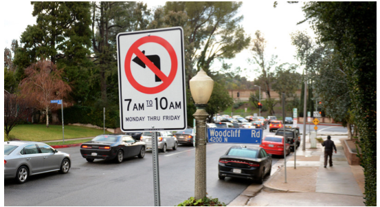
CommentsEIGHT MOST READ - DEEGAN ON LA-While cut through traffic, especially during rush hours, is disrupting neighborhoods cutthroat like, it appears that community voices have not cut into the official City Hall conversation, and there’s an easy solution for that: it’s called a Community Impact Statement.
Every resident of the City is a stakeholder in their local Neighborhood Council. The NCs have a mechanism called a Community Impact Statement (CIS) to submit to City Hall their position on issues that concern their stakeholders. These CISs then become part of the official record and are reviewed with all other documents, motions and reports in the relevant council file when the City Council prepares to deliberate and vote on an issue.
Often, quiet, sleepy neighborhoods suddenly become rush-hour annexes of major boulevards, and there’s surprisingly little community blowback in the way of Community Impact Statements alerting city councilmembers of the opposition to “avoidance apps” like Waze that help drivers avoid heavy traffic by rerouting them through neighborhood side streets.
In this instance, no community advocates, such as residential associations and homeowner groups, have yet used their neighborhood councils to submit community impact statements objecting to how Waze operates and disturbs their neighborhoods. Consequently, there is nothing from the communities and neighborhoods in the official record (called a “Council File”) that City Councilmembers review as part of their deliberations.
The genius of the traffic avoidance app (or the devil if it’s your neighborhood that’s become a popular cut through street thanks to it) is that it streams live reports of traffic near you and suggests which turns to take into and through neighborhoods to avoid congestion. When you have one of these apps turned on, it is actually tracking exactly where you are. It combines that with data from other nearby drivers into algorithms to create an alternative route for you to avoid the busy parts of your route.
It’s not back seat driving, but more like a cyber big brother on your shoulder watching every move you make – collecting all your driving data on the Waze app showing exactly where you are every minute you’re in your car, as long as the app is turned on. This includes private information like what your repeat destinations are, where and when you might drop off and pick up your kids for school, where your home is, where you park every night, and what time you start your day in your car. Civil libertarians may be uncomfortable with this sort of privacy intrusion. Advertisers, however, like to know your habits so they can send pop-up ads to your smartphone for places to shop along your route.
Waze is owned by Google, which aggressively collects data from users of their apps (Waze, Gmail, Google Maps, YouTube, Chrome, Google Search, Google Now, Google Weather, Google Photos, and Hangout) and uses the data it mines and harvests to make a fortune selling targeted users of Google applications to advertisers.
The City Council is trying to figure out how to get a handle on avoidance apps. Councilmember David Ryu (CD4) got the ball rolling with a letter to City Attorney Mike Feuer asking his office “to explore filing suit against Waze, owned by Google LLC, a subsidiary of Alphabet, for creating a dangerous condition in the public right of way.”
That request has evolved into Council File 1800304 “Mobile Mapping Applications (Apps) / Impact to Neighborhood City Streets / Reduce Hazards / Feasibility Report.” A few days ago, the Council’s Transportation committee issued a report recommending that the city’s Department of Transportation (LADOT) “negotiate a data sharing agreement with navigation application companies...and report back to the Council in 90 days.” So, by mid-February, we should have a better idea of what the City plans to do to mitigate this neighborhood nuisance.
That gives plenty of time for concerned community leaders, homeowners and residential groups, and other stakeholders to go to their neighborhood councils and ask for a Community Impact Statement to be submitted to the City Council for insertion into the public record of CF-1800304 so when the council members read the LADOT recommendations about Waze, they will also be able to read what communities have to say as part of the official record.
Very few CISs are ever submitted, and that’s a shame because it’s a way to claim a voice at the council table. It’s an easy process: go to your neighborhood council and ask them to hear your concerns (which is their job) and advocate for you to the City (which is their job). How to Submit a Community Impact Statement instructions lay out the easy steps.
Right now, you don't need an “avoidance app” to work your way around the congestion of so many Community Impact Statements being trafficked to Council File 1800304 (Waze). There are exactly zero CISs in that queue. Today, there are green lights all the way to help speed your CIS about your neighborhood and cut though “streets abuse” to City Hall.
(Tim Deegan is a civic activist whose DEEGAN ON LA weekly column about city planning, new urbanism, the environment, and the homeless appear in CityWatch. Tim can be reached at [email protected].) Edited for CityWatch by Linda Abrams.

