CommentsPLATKIN ON PLANNING- Mayor Quimby shows us how City Hall collusion works.
According to the usual experts, the Wilshire Community Plan area is “zoned-out.” Therefore, the height, mass, and density of many existing parcels should be increased to ensure that the Purple Line’s subway cars are filled with passengers. Buried within this bamboozle is the related claim that this subarea, like the rest of Los Angeles, has no place left for future Angelinos to live.
This story is total nonsense, and the real numbers are just sitting there, ready to debunk these bamboozles.
So, with help from an Excel expert, I cloned the methodology used by the General Plan Framework’s consultant, Envicom, to calculate the zoning capacity – and resulting population -- of the Wilshire Community Plan area. This is precisely where City Planning wants to substantially up-zone the neighborhoods near the Wilshire/LaBrea, Wilshire/Fairfax, and Wilshire LaCienega subway stations.
Even though City Planning has not prepared any similar zoning capacity calculations since the early 1990s, the methodology is straightforward. City Planning staff or consultants could quickly come up with build out populations for all of LA's 35 community plan areas. Totaled together, this would be the buildout population of Los Angeles based on existing zoning, in the range of 8,000,000 people before optional density bonuses are included. With the housing bonuses included, the total zoning capacity of Los Angeles is probably closer to 10 million people. This means that LA’s current population of slightly less than 4,000,000 people could double, without any changes to existing zoning.
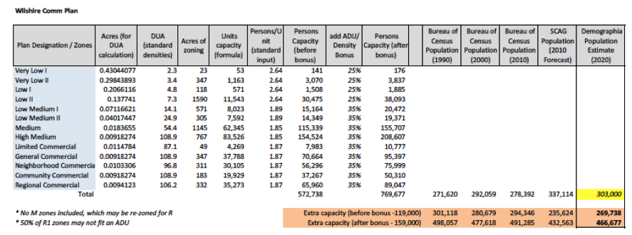
The basic steps to compute zoning building-out:To do this, one first looks at the land use summary for each of LA's 35 Community plans, all of which are posted on line, broken down into acres. As shown in the table below, you then compute the number of units that the Los Angeles zoning code allows per acre and multiply by the number of acres for each land use category.
The Bureau of Census then provides the average number of people in houses and apartments in Los Angeles.
This figure then yields the number of people who could live in a Community Plan area if the existing zoning were fully developed. This is admittedly an approximation because it does not factor in bootlegged apartments, post-2002 zone variances and zone changes, the by-right use of three manufacturing zones for apartments, and Q and related conditions that might limit the development of individual parcels.
Since the City Council adopted the Wilshire Community Plan in 2002, Los Angeles subsequently adopted two density bonus ordinances, one based on Senate Bill 1818 and the other based on voter-adopted Measure JJJ, implemented through Transit Oriented Community (TOC) Guidelines. These ordinances allow residential density to increase by up to 80 percent in projects with five or more units that include specified amounts of affordable housing. (Since no City department ever inspects these affordable units, there is, however, no way to confirm that these units remain affordable.)
Zoning Capacity of the Wilshire Community Plan area: For the Wilshire Community Plan area, the number of people who could be housed through existing zoning is 572,738, understanding that the actual number could be slightly higher or lower based on the factors listed above. Based on the likely population in 2020 of 303,000 people, the means the entire Wilshire Community Plan has unused zoning capacity for 269,738 more people.

If the density bonuses were then added to this base figure, the Plan area’s buildout population would be 769,677 people. The unused extra zoning capacity would then house 466,677 more people. The Wilshire Community Plan could more than double its population without the City Council adopting any zone change ordinances.
These calculations indicate that there is enough existing zoning capacity for all planning scenarios, including the most optimistic population forecasts. This includes City Planning’s/SCAG's (Southern California Association of Governments) forecast that the Wilshire Community Plan area would house 337,114 people in 2010, as compared to the Bureau of Census figure of only 278,392 residents. Under existing growth trends, this gap of 45,000 people will not be filled until 2055, 45 years after City Planning folded SCAG’s population forecast into its 2002 update of the Wilshire Community Plan.
These build out calculations reveal that there is absolutely no need for the City Council to adopt zoning increases for any portion of the Wilshire Community Plan area. This area’s existing zoning can more than accommodate all population scenarios related to the completion of the METRO Purple Line Extension, from Western to LaCienega, in 2023.
Whether the new subway encourages real estate projects on its own, or the Department of City Planning induces new buildings, the unused zoning capacity is sitting there, patiently waiting for developers to apply for building permits. Any developer who wants to construct new apartments or commercial buildings can easily find under-utilized parcels in the Wilshire Community Plan area. t is just sitting there, waiting for their by-right real estate projects. Developers don't even need to apply for zoning waivers to build these large buildings. Existing zoning already permits them.
While these build out calculations apply to the entire Wilshire Community Plan area, not the smaller Purple Line Extension subarea (Beverly Hills on the west, Rimpau on the east, Beverly on the north, and Pico on the south), they nevertheless reveal the same lesson. The subarea lops off the western half of the Wilshire Community Plan area. The excess zoning capacity in this study subarea is roughly half of the Community Plan total. Therefore, existing zoning in the Purple Line Extension subarea could easily accommodate 100,000 more people and with the addition of density bonuses, there would be room for at least 200,000 more people.
Of course, the study area's public services and infrastructure are already failing. The combination of deferred maintenance, increased user demand, speculative real estate projects, and climate change’s droughts and heat waves, have already taken their toll. And, since a highly destructive earthquake is only a question of time, there is no way this study area could accommodate a fraction of its existing zoned capacity for by-right real estate construction and its associated population growth. The ultimate barrier to growth, whether defined as more buildings or more people, is infrastructure. It is not zoning.
Why, then, a major upzoning proposal, if it is not necessary? City Hall’s institutional culture is now built on deregulation, supposedly the new solution for every urban malady. n this simple-minded view of the world, the elimination of regulations, such as zoning, and programs like social services or tree planting, are universal panaceas. Promoting developers’ immediate greed is the tide that lifts all urban ships.
What is the alternative?There is an obvious and less onerous way to promote transit use in this subarea. There is no need to green-light bigger buildings for the well off through up-zoning. The best choice is installing public improvements at and near station areas, along with incentives for local residents, employees, and visitors to use transit, walk, work at home, or bike.
The name for these programs is Transit Oriented Districts or, per METRO, Transit Oriented Communities. The public improvements that could be added to these transit adjacent area are well known. They are, in fact, carefully described in LA City Planning’s remarkable study, Mobility Hubs, A Readers Guide. Its toolbox includes the following, and much more. It should, therefore, be the model for a Purple Line-adjacent program to increase transit ridership, walking, and bicycling without imposing more traffic congestion and deteriorating public utilities and public services on existing and future residents. The local amenities for Purple Line Extension Transit Oriented Districts would minimally include the following, which are also components of METRO’sFirst/Last Mile Strategic Plan:
- Grade separated bicycle lanes and bicycle parking near subway stations.
- Sidewalks improved by street furniture, repaving and widening, ADA curb cuts, lighting, landscaping, and plentiful shade trees adapted to climate change.
- Way-faring signs.
- Kiss ‘n ride and park ‘n ride facilities near subway stations.
- Interfaces for busses, cars, bicycles, and pedestrians at or near subway stations.
- Bus improvements, such as shelters, shorter headways, wi-fi access, and real time apps.
- Transit amenities, such as bathrooms and kiosks.
- Reduced or free fares for transit users, similar to London.
Conclusion: Let’s pursue projects like this that will work. Let pass over up-zoning schemes and scams that enrich developers, line the pockets of decision makers, but not benefit local residents and transit users.
(Dick Platkin is a former LA city planner who reports on local planning controversies for City Watch. Please send comments and corrections to [email protected].) Prepped for CityWatch by Linda Abrams.


