CommentsNEIGHBORHOOD POLITICS - Why are the Neighborhood Councils MIA (missing in action) on the Redistricting of Los Angeles County when so many were engaged in Redistricting the City of Los Angeles?
On Monday, November 29th, 2021, the Los Angeles County Redistricting Commission (LA CRC) will meet in a Special Meeting to discuss three Final Draft maps with the goal of creating a final map on December 7th. There will be a third hearing on their maps on December 1st, 2021, and the final meeting on the maps will be the 4th meeting they are required to hold which will be on December 7th.
The link to the Los Angeles County Redistricting website. Understanding the LACRC for upcoming meetings:
If you go to the page for the upcoming meetings, you will find not only the agendas for the meetings, but you will find documents related to each meeting. For example, for Monday, November 29, 2021, they have posted the Agenda, which explains the Public Comment process, how to join the ZOOM meetings, and the agenda items. On the agenda they show screen shots of two maps – two different versions. These two Final maps are maps B1 and map F.
New Versions of Maps B1 and Map F:
After last Monday’s LA CRC meeting, the Commissioners determined that they would create “Working Groups” to consider these two maps, and that they would work on them in these meetings to make changes based on community input.
On their website as I pointed to the meeting link above, they show new map options that this subgroup of the Commissioners drew with the assistance of their staff and their Executive Director. These new maps are numbered:
- “OP 064 – Modified Option B-1 (Ad Hoc Working Group)
- OP 065 – Modified Option F (Ad Hoc Working Group)
- OP 066 – Modified Option F (Ad Hoc Working Group)
- They also show these links: Option B-1
- Option F
My first question is where are the Neighborhood Councils – why aren’t they weighing into this Commission to protect their Communities of Interest as they did at the LA City Redistricting Commission meetings?
As a San Fernando Valley (SFV) resident for more than 45 years, I know a great deal about the San Fernando Valley. And while I go “over the hill” – the Hollywood Hills-- on a regular basis – whether by the 405 freeway, or through the canyon roads, I do not know the Communities of Interest as well as the local residents, and especially, not as well as the Neighborhood Council members.
I had read in the LA County Redistricting Commissions Outreach Plan:
“Los Angeles City Department of Neighborhood Empowerment (DONE) and its network of 99 Neighborhood Councils (more than 10,000 email subscribers) – introduction through the Los Angeles County Executive Office”
From this, I assume it to mean that the Department of Neighborhood Empowerment (DONE) aka: EmpowerLA would be reaching out to their 10,000 email subscribers to inform them of the LA County Redistricting process. Yet, I have never seen an email from EmpowerLA referencing the LA County Redistricting Commission.
In fact, on an email that I received this week from EmpowerLA, this is what it said regarding Redistricting:
“Redistricting: Final public map hearings are *today* Tuesday November 23 for City Council, LAUSD, US Congress, State elected offices. Who will represent you for the next 10 years? The final public meetings on proposed Redistricting maps for City Council, LA Unified School District, State elected offices, and US Congressional Districts are all taking place *today.* Tuesday, November 23, 2021.”
There is no reference on that email regarding the LA County Redistricting maps or meetings.
A Call to Action:
Since Neighborhood Councils have not been engaged in the LA County Redistricting process to the best of my knowledge, and due to the Brown Act, and other potential time constraints, I hope that these Neighborhood Council Board members will take the time to attend the upcoming three final hearings, and to submit written testimony regarding their Communities of Interest (COIs) to the Redistricting Commission.
There are four ways to make Public Comment on the maps:
- Draw your own maps. That is the link to the mapping software tool. For those who submitted maps for the LA City Redistricting, I must warn you that it is not user friendly, and I have not been able to create my own map to date for LA County.
- Join the ZOOM meetings from the links on the meeting agenda for a specific date. If you join via computer, type into the Q&A box if you want to speak on an agenda item, which item, and your name. For the Monday, November 29th, 2021 meeting, the Maps will be discussed as Agenda Item 5.
- Action / Discussion Items. "5a. Review and Discussion of DRAFT Map Options, including modifications made by the Ad Hoc Working Groups, Commissioners’ observations, and the public’s suggested modifications, and Potential Direction to ARCBridge/Staff Regarding Map Modifications — Co-Chairs Dan Mayeda and Carolyn Williams Here is a visualization of the two current map options – Map Option B-1 and Map Option F (a modification of Map Option A-1) – that are under consideration.”
- Submit written public comments:
““PUBLIC COMMENT
You may provide live public comments on the day of the meeting, workshop, or public hearing. You may also provide written public comments for meetings and public hearings through the General Public Comment Form. If the Public Comment Form does not work or has an error, please contact the clerk at [email protected].
Written public comments submitted by 5:00 PM (PST) the day before a scheduled regular meeting, workshop, or public hearing will be posted to the Los Angeles County Citizen Redistricting Commission website and available to the Commissioners before the meeting. Written public comments submitted after this 5:00 PM (PST) deadline will be uploaded to the website after the meeting, workshop, or public hearing.
You may still submit communities of interest input even after public hearings. The suggested deadline to submit communities of interest input is September 30, 2021. Though the Los Angeles Citizens Redistricting Commission will accept public input through the date it adopts final maps, submitting communities of interest comments by this date will ensure they are received and reviewed before the Commission begins its map drawing process.” The link for written public comments.
- The link for the Communities of Interest form
Why the San Fernando Valley Should be in ONE Supervisorial District:
When I have brought up the San Fernando Valley and why I would like it to be whole at Neighborhood Council meetings as well as at the Valley Alliance of Neighborhood Council meeting earlier this month, I heard things like: “We are already in two Supervisorial Districts – why is this any different?” And I did send out screen shots of previous map options to show how gerrymandered the San Fernando Valley is on some maps, and how West Hills and many other San Fernando Valley communities had been divided in numerous maps.
LA County Redistricting Commission criteria:
Each Supervisorial District is supposed to be considered based on four criteria:
- Equal Population – two million people per Supervisorial District.
- Being Contiguous.
- Being Compact.
- Being Communities of Interest.
But what are “Communities of Interest”?
When I attended the Los Angeles City Council Redistricting Commission (LACCRC) hearings, hundreds of community members, Neighborhood Council members, and non-profit leaders weighed in to explain why a certain Community of Interest should be drawn into a particular City Council District. Those Districts were populated at 260,000 residents as compared to the two million residents of a Supervisorial District.
To me, it is not only about keeping communities together, like China Town, Little Tokyo, Thai Town, or areas around USC, the Staple Center, LA Live, and other testimony that we heard at the LACCRC meetings.
But what about the San Fernando Valley? We also heard testimony at the LA City Redistricting meetings regarding keeping the Armenian Community of Interest together which I believe includes parts of North Hollywood up to Sunland and down to Studio City. I have heard comments about it also including Burbank and Glendale. Shouldn’t that group be included in the San Fernando Valley District as well?
There are Communities of Interest surrounding things including the Burbank airport and their flight paths.
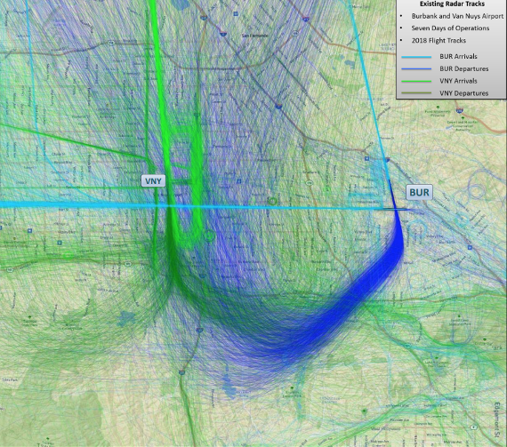
The map above shows the flight paths that the planes take from both the Hollywood Burbank and the Van Nuys airports.
These planes have a significant impact on the quality of lives of these residents in that flight path. This is a reason that the Hollywood Burbank Airport should be included in a map of the San Fernando Valley – currently being designated as Supervisorial District 3.
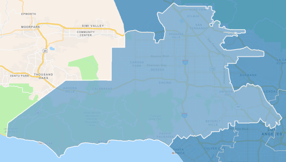
Los Angeles County Service Planning Areas: SPAs
As I listened to the testimony from many people, particularly those who lived in communities in East Los Angeles County, they would reference the need to reach out for help to their supervisor. As I looked at the Service Planning Areas (SPAs), I was horrified to see how far a resident of the West San Fernando Valley would need to go to get to a Public Health Clinic.

This is the Los Angeles County Service Provider Map for the LA County Department of Public Health (LADPH) and the Los Angeles Homeless Services Authority (LAHSA)
This link takes you to SPA 2 – the San Fernando Valley.
| San Fernando and Santa Clarita Valleys |
| Service Planning Area 2 serves the communities of Burbank, Calabasas, Canoga Park, Canyon Country, Encino, Glendale, LA Cañada-Flintridge, San Fernando, Sherman Oaks, Sun Valley, Van Nuys, Woodland Hills, and others |
| Clinics schedules: COVID-19 Vaccine Clinic, click here Nurse Only Clinic, click here Sexual Health Clinic Registration Schedule and Map, click here Flu Vaccine Clinic, click here Health Centers in SPA 2 |
| Glendale Health Center 501 N. Glendale Avenue Glendale, CA 91206 (818) 500-5762 |
|
| North Hollywood Health Center 5300 Tujunga Avenue North Hollywood, CA 91601 (818) 766-3982 |
|
| Pacoima Health Center 13300 Van Nuys Boulevard Pacoima, CA 91331 (818) 896-1903 |
According to this website, the only Health Care Clinics for the San Fernando Valley are in North Hollywood and in Pacoima.
If we had a Supervisor that represented the San Fernando Valley, wouldn’t they work with the LADPH to find other locations in the West San Fernando Valley to provide for those communities in need of health care services?
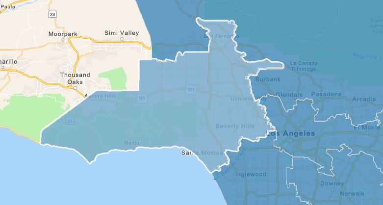
THE RIM OF THE VALLEY – THE NATIONAL PARK SERVICE MAP
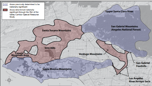
The Rim of the Valley map shows the San Fernando Valley surrounded by the Santa Monica Mountains to the south, the Simi Hills to the west, the Santa Susana Mountains to the north, and essentially the Hollywood Hills to the east.
The Santa Monica Mountains to the south includes a Community of Interest with the Las Virgenes Malibu Council of Governments (Las Virgenes Malibu COG) which includes Agoura Hills, Calabasas, Hidden Hills, Malibu, and Westlake Village.
Since this area is adjacent to the West San Fernando Valley, it makes sense because of the need for additional population, to include this Community of Interest – the Santa Monica Mountain Range to the Pacific Palisades with the San Fernando Valley.
FIRES, FLOODS, EARTHQUAKES, POWER OUTAGES, LOSS OF INTERNET AND PHONE SERVICE
As I remember the Woolsey Fire, I recall who our Elected Officials were that were asking for aide for the communities impacted by this fire. For most of the San Fernando Valley, we fall under the Los Angeles Department of Water and Power for our water and our electric. Most of us are also under similar internet providers such as Spectrum cable, telephone through AT&T and numerous wireless carriers.
The LA County areas of this Las Virgenes Malibu COG share different service providers for their electric, water, and phones. But we all share the LA County Fire Department and the LA County Sheriffs Department when there is a wildfire event in one of our hillside areas.
The San Fernando Valley and the Las Virgenes Malibu COG, along with the Hollywood Burbank Airport are all one large “Community of Interest” within the Rim of the Valley project area.
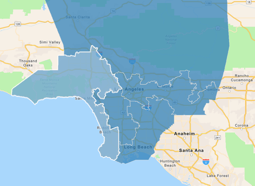
The Three Proposed Maps for Monday, November 29, 2021.
This is how the San Fernando Valley with the Las Virgenes Malibu COG would look in Map Modified Option B-1 OP 064
In this map, Modified Map B-1 OP 064, the most compact map that contains the majority of the San Fernando Valley, most of the San Fernando Valley would be in Supervisorial District 3.
This District, while it does stop before reaching Santa Monica, it does include the “flatter parts of Beverly Hills and West Hollywood which I believe are more well suited with their neighbors along the Wilshire and Santa Monica Blvd corridors. I believe that the line should be drawn at Sunset to keep the hillside potential fire areas together in one Supervisorial District with the San Fernando Valley.
To the east side of the San Fernando Valley, the communities are separated from Burbank while they are the most directly impacted by the air traffic, the car, bus, and train traffic going to this airport. Burbank should be with the San Fernando Valley in Supervisorial District 3.
To the northeast, Sunland – Tujunga are separated from the rest of the San Fernando Valley and placed in the 5th District. They too should be in the San Fernando Valley with their communities of interest.
To the north, in the Santa Susana Mountain Range, parts of Chatsworth, Porter Ranch, and Granada Hills are separated from the San Fernando Valley. They too should be in one San Fernando Valley District that includes the parks and homes below the peak of the Santa Susana Mountain Range. This is another community of interest due to the presence of hundreds of oil wells and the Aliso Canyon Oil Field.
We need a representative that lives in the San Fernando Valley that understands needs and the concerns of the 1.8 million residents of the SFV in regard to the public health impacts of this site and other sites throughout the SFV.
Map F – Two Options:
In Map F – Variation 065 above, the Las Virgenes COG would go south to the Palos Verdes Peninsula. It would divide parts of Santa Monica, and it would include parts of Beverly Hills. The northern boundary would be the community of West Hills on the northwest further gerrymandered to the east, cutting off Chatsworth,
Porter Ranch, Granada Hills from the 3rd Supervisorial District. To the east, it separates Burbank, parts of Sun Valley, parts of Pacoima, and other San Fernando Valleys in the northeast Valley from the rest of the proposed 3rd District. There is no Voter’s Rights Act justification in my mind to gerrymander the San Fernando Valley, the coastal, and the mountain communities of the Rim of the Valley in this manner.
This is Map F – OP 066. In this map above, the Las Virgenes Malibu COG would include Santa Monica and cut off near the Ballona Creek area which is a sensitive ecological area. This again would be Supervisorial District 3 which includes Beverly Hills, but it excludes Culver City which is adjacent to Santa Monica. Wouldn’t these communities be more of a Westside community of interest – a Wilshire Blvd and Santa Monica Blvd Corridor from the Middle of the Wilshire District including Hancock Park, Windsor Square, Century City, Beverly Hills,
West Hollywood, Beverlywood and the other communities of West Los Angeles that follow those two traffic corridors to end in Santa Monica? Westside residents – Santa Monica residents – do you agree with me?
Going north of the Las Virgenes COG area, the map includes West Hills including the Chatsworth Nature Preserve, then it moves in a similar manner to OP 065 where it places Chatsworth, Porter Ranch, and parts of Granada Hills into the 5th District. Yet the 3rd District is gerrymandered to the north to pick up Sylmar including the Olive View Medical Center. The 3rd District appears to pick up parts of Pacoima and Panarama City, parts of Sun Valley (is this the Armenian COI?), yet it separates Sunland Tujunga from its surrounding San Fernando Valley communities, and it also places it into the 5th District. The 5th District on this map also includes Burbank, North Glendale, and Glendale – separating them from the 3rd District where their flight patterns have the greatest takeoff and landing impact.
In Conclusion
Please help me fight to “Keep the San Fernando Valley” and the Las Virgenes COG in one Supervisorial District (3) that will enable us to elect a candidate of our choice that listens to our concerns and is aware of them because they live in the San Fernando Valley and they share our concerns whether they are the intense heat of our summers, Santa Ana winds, wildfires, power outages, access to public health services, access to affordable housing, access to mental health services, and access to water and power, concerns about local environmental issues including protecting wildlife corridors and wildlife crossings, etc.
Be There!
Meeting dates include:
November 29, 2021 – Special meeting
December 1, 2021
December 5, 2021 – Special meeting
December 7, 2021
December 12, 2021 – Special meeting
(Chris Rowe a 43-year resident of West Hills, CA, is a Public Health and Environmental Health Advocate. She was employed at Northridge Hospital, Tarzana Medical Center, and West Hills Hospital while in pursuit of her college degrees. She has a B.S. in Health Education from CSUN. Chris is a former member of the West Hills Neighborhood Council and served on committees of the Woodland Hills Warner Center Neighborhood Council. She writes a blog on the USC / Annenberg School of Health Journalism site. She has written for the Daily News, OURLA.ORG, RonKayeLA.org, and for CityWatch.)