
CommentsNEIGHBORHOOD POLITICS - Redistricting in the City of Los Angeles is reaching an end this month for the Redistricting Commission. From there, their final map will be sent to the Los Angeles City Council for approval.
It was very interesting that at the early meetings that I attended for the LA City Council Redistricting Commission starting with Council District 12 on July 1st, 2021, there did not seem to be a lot of voices. The few that I heard that I knew were active members of the Neighborhood Council system. That was true again at the meeting for Council District 3 on July 15th, 2021.
As of October 1st, 2021, the LA Redistricting Commissioners told the community that they were no longer accepting new maps. Yet many people, including me, continue to use this software that shows the existing City Council boundaries if you want to see them; the Neighborhood Council boundaries which the Commission has stated that they will try to maintain as whole as often as possible; and finally, the LA Times Mapping project overlay which gives different community boundaries that are not the Neighborhood Council boundaries. However, the LA Times map does name communities which the Neighborhood Council boundary lines do not.
DOWNTOWN LOS ANGELES, EAST LOS ANGELES, AND KOREATOWN
These communities seem to be organized and they have made their voices heard by the Commission. The maps have been drawn to protect Koreatown, Thai Town, and other Asian Communities.
There have been numerous comments about protecting the Minority Rights of those in the current Council District 8 and 9 areas. They have made it clear that they want assets that were taken from one Council District to another to be in certain districts as economic drivers.
And the communities of Eagle Rock and Highland Park have made it clear that they want to be “Kept whole” – “Keep Us Whole.”
In my last article, I asked: “Does Commission Think San Fernando Valley is Too Stupid to Understand Redistricting Manipulation?”:
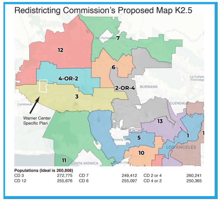
The Current Map: Version K 2.5:
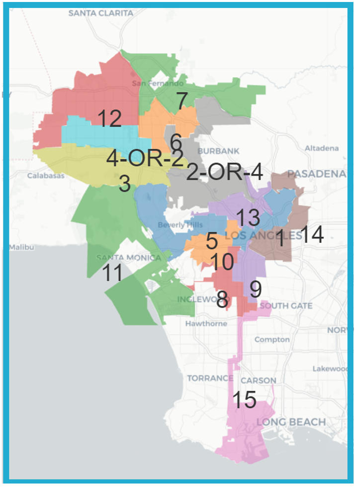
Los Angeles City Redistricting Commission Map K 2.5 – 1: October 13, 2021:
REDISTRICTING LOS ANGELES:
What I am observing is various knowledge of the Redistricting process. Non-profits and business interests seem to be aware of redistricting, but in many cases, the average resident seems unaware of the importance of this process.
As I have written my four previous articles in CityWatchLA on Redistricting, I have shared them with neighbors, friends, and people that I have worked with in multiple Neighborhood Councils.
In the meantime, what I am seeing happening is that meetings for the LA City Redistricting Commission (LACCRC) are often on the same day and at the same time as not only the LA County Redistricting Commission (LA CRC), but also, in the case of the State of California Redistricting Commission – “We Draw the Lines” (CCRC), there are also meetings being held on the same day for our Congressional Seats, our State Senate Seats, and our State Assembly seats. I noted that – as I write this on October 13th, 2021, that all three entities will be meeting at some time today.
On the most recent five calls that I have been on, there has usually been 75 minutes reserved for “Public Comment” at the LACCRC for the LA City Council District maps.
Last week, on October 6th, 2021, I asked my husband to attend the LACCRC for me while I went to the LA County Redistricting Committee meeting. He said that he was able to speak, and in his one minute of time, he was able to make two points:
Community Plans:
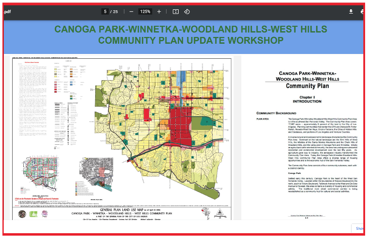
This is the Canoga Park – Winnetka – Woodland Hills – West Hills Community Plan. This slide was taken from the Southwest Valley Community Plan Update.
Why is this important?
The Los Angeles City Planning Commissioners as well as the Los Angeles City Councilmembers and their staff should make themselves aware of these community plans and the updates to them.
For example, when they are drawing West Hills into CD 12 – even if it “fits” in terms of population and the fact that it is “contiguous with Chatsworth”, it does not make West Hills a “Community of Interest” with the Northeast Valley Communities that border the 405 freeway such as Granada Hills and North Hills.
I was able to watch a video on the Southwest Community Plan Update geared specifically to the “Canoga Park – Winnetka – Woodland Hills – West Hills Community Plan.” You can find it here: https://lacity.webdamdb.com/embedvid.php?embedAssetId=okiEpNj7xaf1&apm=0
My husband was also able to enter into his oral testimony and his written Community of Interest testimony by email that West Hills is also a part of the Warner Center 2035 Neighborhood Protection Plan (NPP) which is a part of the Warner Center 2035 Specific Plan: https://planning.lacity.org/plans-policies/overlays/warner-center-2035-specific-plan
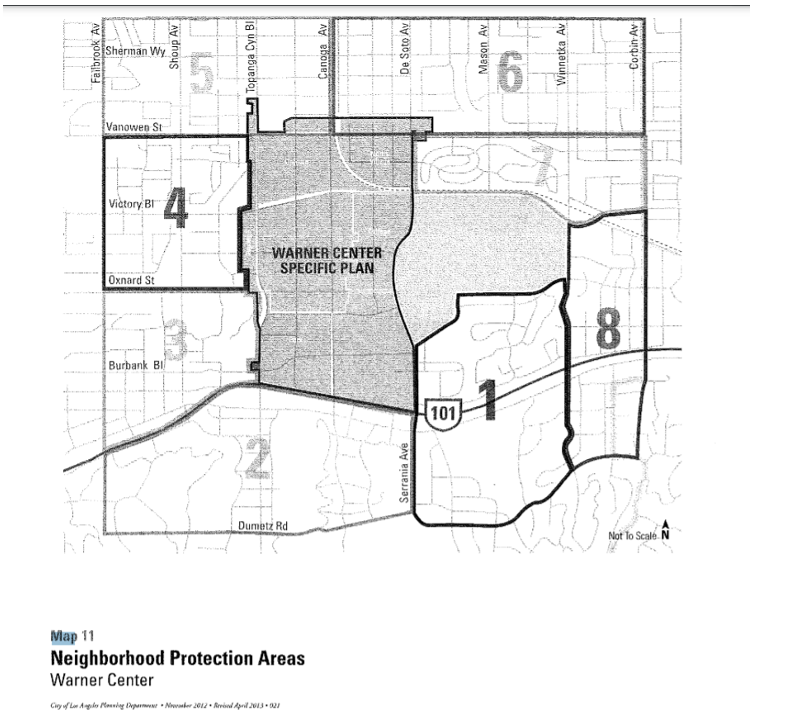
West Hills is represented in part in Areas 4 and 5 of this Neighborhood Protection Area map. Canoga Park is represented in parts of Areas 5 and 6; Winnetka, I believe, is represented in Area 6 of the NPP. I believe that areas 7, 8, 1, 2, and 3, and part of 4 would all be parts of Woodland Hills.
For these two reasons alone, I believe that West Hills should be in any map which should also include Canoga Park, Winnetka, and Woodland Hills.
Resources:
I chose my photo of the Los Angeles Police Department (LAPD) Topanga Station because this is the police station that serves all of these communities – West Hills, Woodland Hills, Canoga Park, and Winnetka.
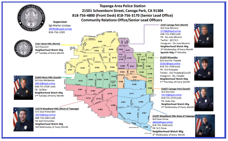
This is the map of the Los Angeles Police Topanga Division map and the Senior Lead Officers (SLOs) that are assigned to each area.
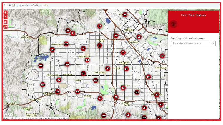
This is a Los Angeles Fire Station map that is interactive that I zoomed to show most of the stations in the West San Fernando Valley. That map can be found here:
Map K 2.5 – 1:
Members of the Woodland Hills Warner Center Neighborhood Council (WHWCNC) have considered the two previous maps that the LACCRC had considered – map K 2.5 and map L. For some reason, map L has been taken off the table, and currently, the LA City Redistricting Commission is only considering what is now called K 2.5 – 1.
This is a link to the recommendations of the WHWCNC’S Woodland Hills Issues and Policies Committee aka: WHIP Committee’s recommendations to their Board to consider on their agenda tonight, October 13, 2021:
From that report by the WHIP Committee, you see their drawing of Map K 2.5 with Warner Center Specific Plan shown inside their area:
Warner Center Specific Plan rough boundaries drawn by WHWCNC WHIP Committee members.
Map 57666:
I read the audio transcript of the LACCRC meeting on Saturday, October 9, 2021. A number of people mentioned Map number 57666. That map came from the WHIP Committee’s report to their Board – the WHIP Committee meeting had that map on their agenda for their committee meeting on October 7th, 2021.
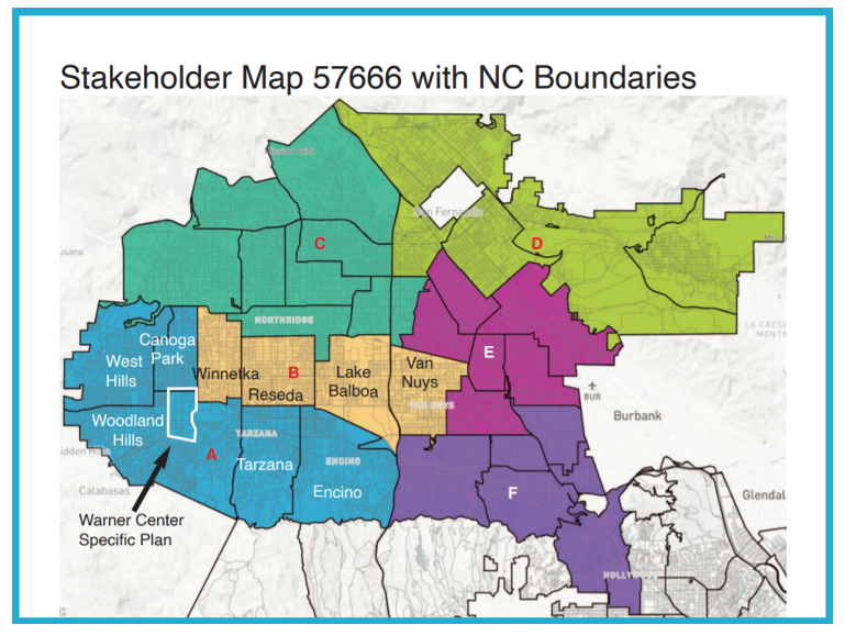
This map shows the San Fernando Valley which has not had much attention from the LACCRC until recently because of the lack of time for public testimony (75 minutes for 400 – 500 + stakeholders).
I support this map of the San Fernando Valley because it does include West Hills, Canoga Park, and Woodland Hills all in one City Council District (Letter A – shown in red here).
Now for your consideration!
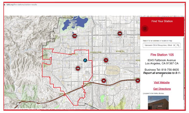
This map shows the LAFD station that would respond if there was an incident at the intersection of Vanowen Street and Shoup Avenue, West Hills, California.
Imagine for a moment – if we have Map K 2.5 with West Hills in Council District 12; Canoga Park in Council District 4 or 2; and Woodland Hills in Council District 3. Each of those City Council Districts will meet at that one intersection!
The LAPD Topanga Station would also be responsible for any incident at that intersection as well.
So, if we have another “Northridge Earthquake of 1994”, or if we have another “Woolsey Fire” which started at the Santa Susana Field Laboratory shown on this map due west of the Chatsworth Nature Preserve which is 80 % in West Hills – which Councilmember’s office is the LAFD Captain or the LAPD Captain going to talk to first?
Other Map Considerations:
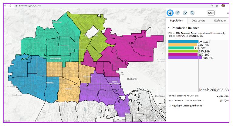
This is a “Districtr” map that I drew of the San Fernando Valley with the input from Community of Interest groups. If you notice, with the blue map on the left, the combination with West Hills, Canoga Park, Winnetka, Woodland Hills, and Tarzana together you achieve an almost perfect district – a population of 259,366 when the ideal is 260, 808.33. However, if you maintain the plans that you want to keep Mulholland as the southern boundary with little population going to the south, then you must balance other communities like Reseda which have a population of roughly 80,000 people between Council Districts.
Then there are also the wishes of some residents of the San Fernando Valley to use the 405 freeway as a dividing line between certain communities such as North Hills. So, by taking West Hills and North Hills East out of CD 12, CD 12 only has a population of 219,807.
Encino Neighborhood Council has asked on more than one occasion to be in the same Council District with the Sepulveda Basin and Lake Balboa. I drew that district together in a golden color in the center.
I tried moving Reseda into Council District 12 which would place its population at over 299,000. And that would throw off the contiguous communities of interest that they have to the east and to the south.
In purple, you see the communities of interest. I believe that in the last testimony, the Armenian Community asked for Valley Glen to be kept whole with North Hollywood.
Also in purple, the “Entertainment Community of Interest” is maintained by keeping North Hollywood with Toluca Lake, Studio City, Sherman Oaks, and south into the Hollywood Hills. I believe that this map keeps many of the Hollywood Hills’ areas whole – but that is to be determined by future drafts of K 2.5 – 1.
In Conclusion:
While I have drawn my own map by listening to the concerns of many Neighborhood Councilmember who know their “Communities of Interest”, and to the testimony of other stakeholders, I support Map 57666 due to its inclusion of West Hills with Woodland Hills and Canoga Park, and because it is drawn in a manner that conforms as closely as possible to the Mulholland boundary on the south; the San Fernando Freeway for the West San Fernando Valley, and only one or more small Neighborhood Councils going south of Mulholland in the “Entertainment District”. And finally, I find on that map 57666: https://districtr.org/plan/57666 a Maximum Population Deviation of only 5.3% for the San Fernando Valley as drawn.
Note: For all of the City Council Districts that have been redrawn, there should be a consideration that new Council Districts will never have had a City Council election. Therefore, any new Council District that is created in the San Fernando Valley would require an election in 2022.
(Chris Rowe a 43-year resident of West Hills, CA, is a Public Health and Environmental Health Advocate. She was employed at Northridge Hospital, Tarzana Medical Center, and West Hills Hospital while in pursuit of her college degrees. She has a B.S. in Health Education from CSUN. Chris is a former member of the West Hills Neighborhood Council and served on committees of the Woodland Hills Warner Center Neighborhood Council. She writes a blog on the USC / Annenberg School of Health Journalism site. She has written for the Daily News, OURLA.ORG, RonKayeLA.org, and for CityWatch.)