
CommentsLOCAL GOVERNMENT-This is a map of Los Angeles County with the dates of the Los Angeles County Redistricting Committee meetings by area.
The first Los Angeles County area specific meeting was on June 14, 2021; it is shown here as location “A”. The second area specific meeting was on June 23, 2021; it is shown here as location “D.”
A meeting is scheduled June 28, 2021, for area “I” which is shown in purple on the above map. There are regular meetings dates that are not on this map. To date, I believe that these meetings have been via ZOOM. It is my understanding that later in the summer, the Redistricting Committee will hold hearings in these communities. Please see the Los Angeles Redistricting website here.
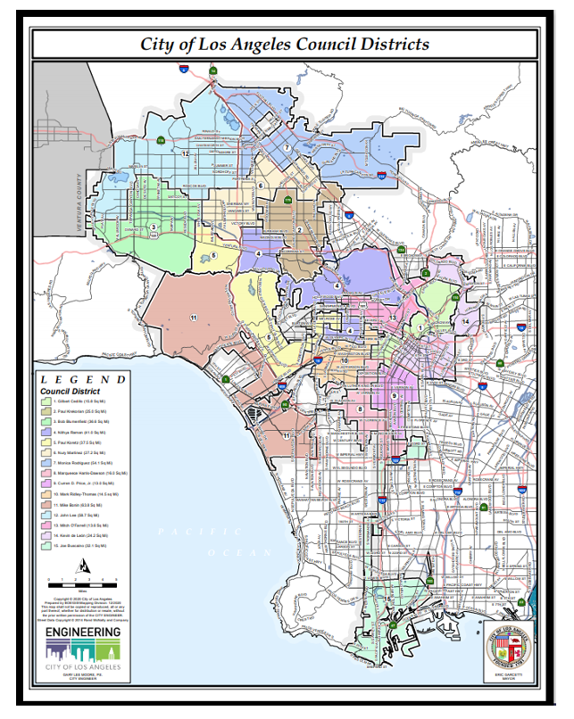
Above is a current map of the City of Los Angeles by City Council District. Of importance to note that meetings specific to Council Districts begin on July 1, 2021.
The first Districtwide meeting is for Council District 12 on July 1, 2021. Please see the Los Angeles City Redistricting Committee website here.
Finally, the State of California Redistricting Commission will be redistricting our Congressional Districts, our State Senate Districts, and our State Assembly Districts. This Commission has been having regular meetings.
Unfortunately, the meeting for the County of Los Angeles was Sunday, June 26, 2021. However, the State Commissioners request that you submit your comments to them about “your community.” You can find out more on the State Redistricting here.
 “We Draw the Lines” – California Citizens Redistricting Commission map by Outreach Zone.
Redistricting: Why is this important to me?
After the 2010 Census, I was a member of the West Hills Neighborhood Council. I was approached by the President of a neighboring neighborhood council. A member of that neighborhood council had drawn a map.
A few of the members from the West Hills, Woodland Hills, and Encino Neighborhood Council met to consider this map. The map by this neighborhood council member was taken to the West Hills Neighborhood Council. At the time, West Hills was split into two City Council Districts – Council District 3 which included West Hills to the area south of Roscoe Blvd, and Council District 12, the area north of Roscoe Blvd.
As a Neighborhood Council, we voted to be included in this map area (I do not have a copy of that map at this time), and at another time, we voted to the best of my recall, either to be completely in Council District 3, or to remain split between the two Council Districts.
What was the result – West Hills was completely drawn into Council District 12! This was not an option that I had ever considered or was ever discussed at any of the Redistricting Commission meetings that I attended!
‘Contiguous, Compact, and Communities of Interest’
The rules of “contiguous, compact, and communities of interest” apply whether to the State Redistricting process, to Los Angeles County Redistricting, as well as to the Redistricting of the City of Los Angeles.
What do these terms mean? For example, West Hills is contiguous with Woodland Hills on the south and east; it is contiguous with Canoga Park to the east of Shoup, and the south side of Roscoe east of Shoup. West Hills is contiguous with Chatsworth where the lines are drawn at Nordhoff and Topanga going west through the Chatsworth Nature Preserve to the Los Angeles City line.
Compact should mean drawn close together. But each of these districts is based upon population, being contiguous, and communities of interest.
Furthermore, to the best of my understanding, these districts cannot be drawn in California to give a political advantage to any particular political party.
And finally, while ethnic diversity must be considered, it is my understanding that maps should not be drawn in a manner that gives one ethnicity or race a majority of the population to the detriment of other people of a different ethnicity or race. This is to allow for an equal opportunity when voting for future elected officials.
Council District 12
If you look at the current City of Los Angeles map which is the second image from the top, for Council District 12 (CD 12) shown in light blue, you will notice that most of CD 12 is along the base of the Santa Susana Mountain range or also known as the North San Fernando Valley. Yet it drops down to the southwest to add in West Hills, and it goes to the north to incorporate other communities. The lines do not follow any specific community lines based on Neighborhood Council boundaries. The lines are not straight moving from west to east.
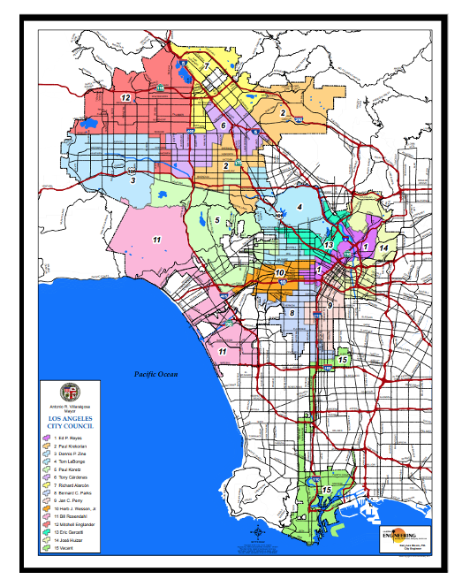
Los Angeles City Map from 2003
This was the City of Los Angeles map drawn in 2003. On this map, Council District 12 is shown in red. In this map, West Hills is divided, and Council District 3 as shown here is “Contiguous and Compact.” Council District 12, on the other hand, drops down southward into an area more contiguous with Council District 3 and with Council District 6.
To me, Council District 6 on this map above is completely gerrymandered as are numerous other Council Districts on this map.
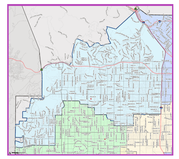
Council District 12 Map
Council District 12 map shown in light blue. While West Hills as stated previously is contiguous with Chatsworth at the intersection of Nordhoff and Topanga going west as mentioned earlier, what does West Hills have in common with the other northern communities to the northeast?
While some residents who live in the North part of West Hills may send their children to schools in Chatsworth, and while West Hills and Chatsworth share the Chatsworth Nature Preserve, what other aspects do they have as “communities of interest”?
Council District 3
In the first map second from the top of the City of Los Angeles, you can see Council District 3 with Woodland Hills to the West and moving north into Canoga Park, and Winnetka.
In the second map of Los Angeles, drawn in 2003, you see West Hills as a large part of Council District 3, and you see a straight line along Roscoe Blvd to where CD 12 drops down.

Council District 3 Map
Council District 3 map taken from LA City map to show street boundaries.
To me this map of Council District 3 (CD3) looks as if West Hills is “cut out” of CD 3. West Hills is the far west central part of the San Fernando Valley.
How I would like Council District 3 Drawn to make it a “Contiguous, Compact, Communities of Interest District
West Hills is a part of the “Canoga Park, Winnetka, Woodland Hills, West Hills Community Plan.”
South of Roscoe Blvd.

Canoga Park, Winnetka, Woodland Hills, West Hills Community Plan map
West Hills is a part of this community plan today. However, the West Hills Neighborhood Council has asked that it be “whole”; not divided into two community plans – this plan, and the Chatsworth / Porter Ranch Community Plan which is for the area north of Roscoe for West Hills and other communities. West Hills is being divided in the new Southwest Community Plan as well.
I propose that Council District 3 and the Southwest Community Plan areas be drawn based on Neighborhood Council boundaries. Neighborhood Councils are supposed to represent their communities of interest.

Future Council District 3 proposed map (by Chris Rowe) to include the Neighborhood Council boundaries of West Hills, Woodland Hills / Warner Center, Canoga Park, Winnetka, Reseda, and Tarzana. These communities are “Contiguous, Compact, and Communities of Interest.” The boundaries to the north and east have been highlighted in black to indicate that these communities should be “whole” when also creating the Southwest Community Plan map.
To be continued: Redistricting Los Angeles County – Part 2.
(Chris Rowe a 43-year resident of West Hills, CA, is a Public Health and Environmental Health Advocate. She was employed at Northridge Hospital, Tarzana Medical Center, and West Hills Hospital while in pursuit of her college degrees. She has a B.S. in Health Education from CSUN. Chris is a former member of the West Hills Neighborhood Council and served on committees of the Woodland Hills Warner Center Neighborhood Council. She writes a blog on the USC / Annenberg School of Health Journalism site. She has written for the Daily News, OURLA.ORG, RonKayeLA.org, and for CityWatch.) Edited for CityWatch by Linda Abrams.