CommentsNEIGHBORHOOD POLITICS-As a former Neighborhood Council Board member, I think a great deal about our local government and how the actions of the various elected officials who represent me impact our lives.
The County of Los Angeles has announced the names of their new Redistricting Commissioners based on the 2020 Census.
In 2011, when the City of Los Angeles was in the process of redistricting, I was still a member of the West Hills Neighborhood Council. As a Board, we had voted for the community of West Hills to be completely contained in Council District 3 or divided between Council Districts 3 and 12 based on an arbitrary boundary in West Hills that places the area south of Roscoe into the “Canoga Park, Winnetka, Woodland Hills, and West Hills Community Plan.”
The area north of Roscoe is placed into the Chatsworth-Porter Ranch Community Plan. As the City Planning Department has reviewed our “Canoga Park, Winnetka, Woodland Hills, and West Hills Community Plan,” the West Hills Neighborhood Council has asked City Planning to keep West Hills “whole.”
I don’t know when a Commission will be created for the next Redistricting of the City of Los Angeles. But that is also a factor our Los Angeles County Redistricting Committee should keep in mind. They should try to keep historical communities “whole.”
When we examined guidance on how the City should be redistricted, some guidelines indicated that communities should be “Contiguous, Compact, and Communities of Interest.”
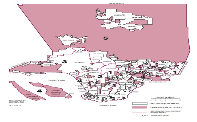
Gerrymandered: When I look at the map above, I can’t help but feel that at some point it was gerrymandered. Why do I say that? Why would you have a district with its western boundary in West Hills at the Ventura County line, and its eastern boundary at the San Bernardino County boundary? What does West Hills have in common in the 5th District north of the Santa Susana and San Gabriel Mountain ranges?
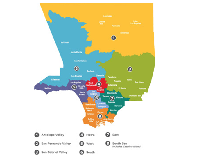
Above is the map for the Los Angeles County Department of Health Service areas. These areas are particularly important during our pandemic. While I believe that these areas are more “Contiguous, compact, communities of interest,” again, I see Area 2 going from Calabasas well beyond the Santa Clarita Valley.
There are currently five Los Angeles County Supervisor Districts. They serve, according to their website, they serve 88 incorporated Cities, 4,084 Square Miles, a $28 Billion Budget, and an estimated population of 10,170,292 residents.
Keeping in mind that this population is an estimate, and the boundaries will remain in place for another decade, I would like to propose eleven Supervisorial districts. This would give the people better access to their elected representatives.
If each District represented roughly one million people rather than two million, the Districts could be more “Contiguous, Compact, and Communities of Interest.”
The 5th District Election in 2016
I attended a debate in 2016 for the 5th District race which was won by Katheryn Barger. Afterward, I asked various candidates what they knew about West Hills and the Santa Susana Field Laboratory, which is an important issue to our community. It appeared that many of the candidates were not aware that portions of West Hills were in the 5th District.
Later, I contacted the Los Angeles County Registrar Recorders office to ask why West Hills did not appear on the 5th District map at that time. I learned that the 3rd District maps placed West Hills completely within its boundaries, which was also an error.
My Goal
With a reduced population size and eleven supervisorial districts, elected officials’ offices could be placed within the physical boundaries they represent, making them more accessible to their constituents.
For example, I would like to see the San Fernando Valley, a community with a population of roughly 1.75 million according to Congressmember Brad Sherman’s website, have lines drawn that would encompass the complete West San Fernando Valley. This would make this geographic group “Contiguous, Compact, and a Community of Interest” rather than a district that literally divides many local San Fernando Valley Communities.
Tools that could be used for the Redistricting Commissioners:
- The Commissioners could request copies of the existing or proposed community plans from Los Angeles City Planning.
- Another tool is the Rim of the Valley Map. This map would place contiguous mountain and ocean communities in one geographic area. Since this map probably encompasses more than two million people, one district could be similar to the district in purple along the Santa Monica Mountain range to the south. Below is the Rim of the Valley map from Supervisor Kuehl’s site.
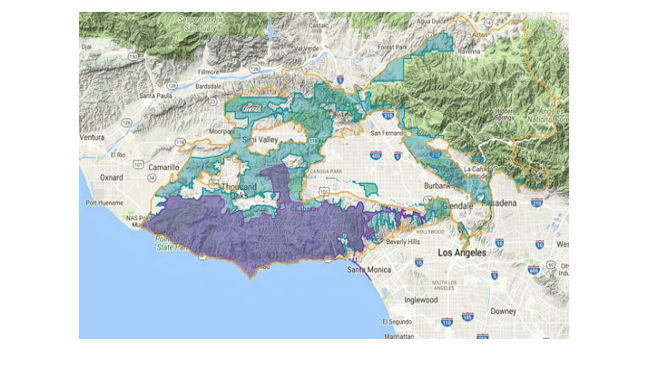 How many people would live in an area that starts at Pt. Mugu on the South west and extends to Santa Monica near Sunset? How many residents would live in this area south of Mulholland Drive?
- What about the existing Los Angeles City Boundaries? Where are they relative to the County Boundaries?
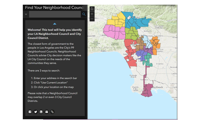
- Another tool that could be utilized by the Redistricting Commissioners is the Neighborhood Council system map. (below)
- Other important tools that the Redistricting Commissioners could use are from the California Office of Environmental Health and Hazard Assessment (OEHHA) maps. These maps have census tract data which include the population characteristics, pollution burden, and the overall results of these impacts on a community.
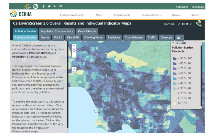
Above is a screen shot of Los Angeles County for CalEnviroScreen’s Overall Results (boundaries for the County are not shown.
Here is a rough screen shot of Los Angeles County based on Population Characteristics.
Each tab in the map looks at various characteristics which would help to identify Environmental Justice communities.
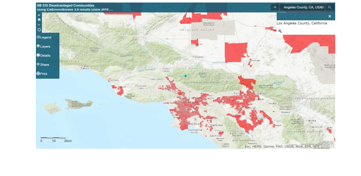
- Another OEHHA tool is based on State Law SB 535: Disadvantaged Communities. See below.
- Another tool that the Redistricting Commission should consider is from the California Air Resources Board (CARB) based on Assembly Bill 1550 -Gomez – Low Income and Priority Populations.
Certain populations are especially vulnerable to the impacts of climate change. At least 35 percent of California Climate Investments must benefit these populations, which include disadvantaged communities, low-income communities, and low-income households, also known as “priority populations.”
My Conclusion: In light of our growing population, the impacts of air quality, climate change, socioeconomic status, minority status, and now, the additional burden of a pandemic, it would be nice to divide our almost eleven million population in an equitable manner, and to have Elected Officials live in close proximity to their constituents so that they can really understand what the residents are experiencing whether it is the air quality near the Harbors, the air quality near the refineries, the problems associated with the Exide site, the issue of homelessness, and the impacts of air quality, heat, cold, and other problems on the homeless population.
Can the current five member Los Angeles County Board of Supervisors vote to request the Redistricting Commissioners to create eleven equitable Supervisorial Districts instead of five? Or would that require a ballot initiative?
(Chris Rowe, a former health care employee who has worked at Northridge Hospital, Tarzana Medical Center, and West Hills Hospital has a B.S. in Health Education. She is a 42-year resident of West Hills. She has written for the Los Angeles Daily News, RonKayeLA.org; OurLA.org; and CityWatch. She has a blog on the USC/ Annenberg Center for Health Journalism website and can be reached at [email protected]) Edited for CityWatch by Linda Abrams.